


gorges de la langouette

Titinechris
User
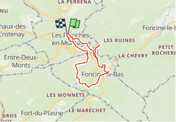

Length
12.8 km

Max alt
892 m

Uphill gradient
327 m
Km-Effort
17.2 km

Min alt
696 m

Downhill gradient
337 m
Boucle
Yes
Creation date :
2024-08-08 07:12:24.726
Updated on :
2024-08-08 07:12:48.864
3h54
Difficulty : Difficult

FREE GPS app for hiking
 SityTrail
IGN / Geographical institutes
SityTrail Plus
The world is yours!
About
Trail Walking of 12.8 km to be discovered at Bourgogne-Franche-Comté, Jura, Les Planches-en-Montagne. This trail is proposed by Titinechris.
Positioning
Country:
France
Region :
Bourgogne-Franche-Comté
Department/Province :
Jura
Municipality :
Les Planches-en-Montagne
Location:
Unknown
Start:(Dec)
Start:(UTM)
270930 ; 5171339 (32T) N.
Comments